Phu Lang ka National Park, about 31,250 Rais or 50 squares kilometers, covers the area in Baan Pang District, Nakhon Phanom Province, and Sega District, Nong Khai Province. There generally are productive forests such as montane forest, rain forest, mixed forest and deciduous forest. The area is the source of water, habitat of a number of animals, and has many wonderful places to visit such as cliffs, caves and waterfalls. Despite the beautiful scenery and productive forest, the area also has varieties of life and environment.
The area has three mountains, overlapping each other and lying north and south, alternating with mountain ranges and small mountains along with Khong River. The highest peak is about 563 meters above sea level. This mountain Range is the source of many rivers which flow to Khong River in Baan Pair District and are valuable for agriculture of people around Phu Lang ka National Park.
Cliffs
Phu Lang ka is a stand alone mountain which has two beautiful cliffs in other side, these are, Phu Lang ka Tai and Phu Lang ka Nuar. And on the top of it lay beautiful plains of rock.
Phu Lang ka Rock
There are many interesting rocks such as; Kong Khao Si Boon Nauo which is a group of rock look like a pile of rice-straw and has a look-like rut of cart nearby; and Koge Tala Pat which has large plain of rock consist of carved rock look like Tala Pat (a priest's tool for sermoning) and carvings on rocks.
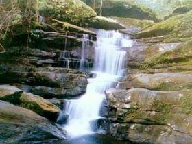
Tard Kham Waterfall
Tard Kham Waterfall is not very cascade cascading four levels. There is also a small rock-floor nearby for recreation. The lowest level is a pond which has water all the year round. It is well known by visitor from around the area such as Nong Khai Province, Sakhon Nakhon Province, Udon Thani Province etc. Everyday has about 100 visitors, and, especially, on weekend or holiday there is about 400-500 visitors.
Tard Phor Waterfall
Tard Phor Waterfall is a very beautiful cascade each of which layers higher than 10 meters; especially at second layer is 30 meters high. There is clearly seen from the road Nakhon Phanom - Nong Khai in rainy season. Despite the waterfall, the area also consists of many wonderful places such as big and small caves, for examples, Ya Cave, Por Nga Cave, Tar Tad Cave, Gear Cave and Ajarn Wang Cave.