|
Tat Ton National Park located on Phu Lan ka Mountain range in Phu Lan Ka conservation forest. The park has total area of 217.18 km2. It was designated to be National Park on the 31st December 1980 as the 23rd national park of Thailand. This area is a part of Lum Pa Tao river source and flow to meet Shee River of which utilize Esarn People.
It is on Phu Lanka Mountains. Most of the land is on the highland and surrounded by mountains. In the central is lowland. There are three peaks: Phu Kaset, Phu Dee, and Phu Youk. Each peak is the water sources as well as Dtan-dta-nod Waterfall. The river is flowing though Muang District, Chaiyapoom.
Chao-Por Dtad-dton (Pu-dung) Shrine
It is located nearby Dta-dton waterfall. People really respect because Pu-Duang lived in the same period of Chao-Por Praya Lae (the first governor of Chaiyapom). He liked to live simply, contentiously, as well as liked to hike around Lan-Phu-Ka Mountain, and had knowledge about the herbal. He helped many villagers whenever they got sick. Besides he knew some magic and being respected by villagers since he died for long time ago.
Pa-kerng and Pha-Buddha-Chaiyapoom Pitak
It is the highest point on Chaiyapoom-Nong Bua Dang Road nearby No 17th kilometer. It is very beautiful point, and can see Nong Bua Dang District at the north, and Kao Kiew Wild Lives Reserved Park. Nearby Pa-Kerng is Pha-Buddha-chaiyapoom-Pitak faced to the cliff at north.
Pha Eang Waterfall
it located on cliff in Ban Shee Long Nuea, the west of the Park, and 3 km. from highway 2159 (Chaiyaphum - Nong Bua Daeng). There is an 800m nature trail to the waterfall surrounding with dry evergreen forest, which suit for recreation. Pha Song Shun Waterfall: above Pha Eang Waterfall. The 2 step Waterfall has 5m, high.
Pha Nit Waterfall
is about 1 km. from Pha Eang Waterfall. Its character like Pha Eang but smaller.
Tat Fah Waterfall
located in Na Seao Sub-district, about 4 km. north from Ban Na Wang. It characterizes nature slider stone field, with 80-90m, long. In rainy, it is the most beautiful because the surrounding is peace that favors people to visit.
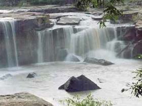
Tat Ton Waterfall
it is considered to be one of the most beautiful waterfall of Esarn. About 21 km. from the town, the transportation is convenient. The area consists of Lan Hin (Stone Field) and has water flows all year.
|