|
|
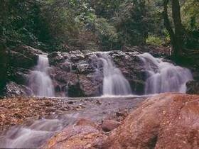
Doi Chong National Park is situated in the areas of Sop Prap District, Thoen District, and Mae Phrik District of Lampang Province, and Li District of Lamphun Province. The geographical features of the National Park consist of high mountains. Doi Chong is the highest mountaintop of the National Park (1,339 meters above the sea level) with beautiful scenery and various kinds of forests including mixed forests, arid evergreen forests, and pinery, and being the source of streams and rivers. The topography of the National Park consist of small sized and large sized mountains, extending from the north to the southwest of the area. These mountains are the sources of many gullies flowing into Wang River (Wang River is the main river of Lampang Province and also being the water source for many reservoirs such as Maeprap Reservoir, Huai Maepu Reservoir, Mae-yong Reservoir, etc. In general, the topography of the area consist of stony mountains with decorative minerals, zinc, granite, and marble.
|