|
Nunthaburi National Park covers the areas of Tha Wangpha District, Muang District, and Baan Luang District of Nan Province within an approximate area of 548,125 rai. The National Park consists of virgin forests and abundant natural resources, biological diversity. The National Park is the source of rivers and having prominent natural tourist attractions.
The geographical features of the National Park consist of high mountains, extending northwards. The National Park is situated in the western part of Nan Province until reaching the Lao People's Democratic Republic. The site of the National Park is approximately 300-1,674 meters above the medium sea level. The average slope of the site is approximately 50%. Yod Doi Wao is the highest mountaintop of the National Park (at the height of 1,674 meters above the medium sea level).
Baan Namki Artesian Spring
Baan Namki Artesian Spring is located at Baan Namki, Tambon Phathong, Tha Wangpha District, Nan Province. The Artesian Spring has an approximate temperature of 80?C and can potentially be developed as a tourist attraction for mineral bathing.
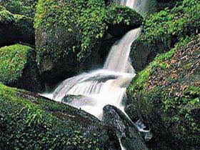
Doi Mork Waterfall
Doi Mork Waterfall is a beautiful, small-medium sized waterfall located in Tambon Ruang, Muang District, Nan Province, with flowing water throughout the year. The Waterfall is ideal for bathing and recreational activities.
Habitations for Pi Tong Leung Tribe
The abundant areas of the forests in Baan Luang District and Tha Wangpha District are habitations for "Pi Tong Leung" tribe, a wandering human tribe living in the forests.
Huai Prig Waterfall
Huai Prig Waterfall is a 4-step, small-medium sized waterfall with flowing water throughout the year. The Waterfall has precipitous streams, reefs, and beautiful cliff sheds. The Waterfall is located in Tambon Baan Pi, Baan Luang District, Nan Province.
Santisuk Waterfall
Santisuk Waterfall is a 5-step, small-medium sized waterfall with flowing water throughout the year. The Waterfall is located in Tambon Saen Thong, Tha Wangpha District, Nan Province.
Song Kwae Waterfall
Song Kwae Waterfall is a small-sized waterfall situated in a virgin forest, which should be developed as a route for natural study. The Waterfall is located in Tambon Sanien, Amphur Muang, Nan Province.
Tad Fa Rong Waterfall
Tad Fa Rong Waterfall is situated in the area of the Pa Namyao-Namsuad National Conserved Forest in Tambon Saen Thong, Tha Wangpha District, Nan Province, which has been surveyed for the establishment of Nanthaburi National Park. The Waterfall is a 3-step large-sized waterfall with flowing water throughout the year and being the source of rivers. Doi Wao mountain range is situated in Baan Namki, Tha Wangpha District, Nan Province, approximately 4 km away from the site of artesian spring.
|