|
Formerly, Mae Wong National Park was the centre of hill tribe for example Hmong, Yao, Muzer and Karen. The park was declared a national park on 14th September 1987 as the 55th park of Thailand. This 894 km 2 park is located approximately 350 kilometers northwest of Bangkok in the provinces Nakon Sawan and Kampaeng Phet, West Thailand.
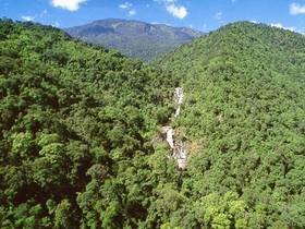
The park is very rugged and hilly along Tanon Thong Chai mountain range, especially on the north and west. With the highest peak at 1,964 m. above sea level it is one of highest mountain ranges in the west of Thailand. Three main rivers of which the Mae Wong River is the biggest drain the park.
Chong Yen (Km. 93 )
Km. 93 Chong Yen: located 28 kilometers from the headquarters. Km. 93 is the highest peak of Klong Lan-Umpang road so the weather is cool and windy. Besides, the breath taking views this is also an excellent place for bird watching.
Kaeng Pa Nang Koy rapids
Kaeng Pa Koy Nang rapids: Located some 1,400 meters from the headquarters, this is an ideal site for a picnic and bathing. About 350 meters from the rapid there is Pa Nang Koy Waterfall-the small fall but beautiful. Moreover, there is campground near the waterfall.
Mae Rewa Waterfall
Mae Rewa Waterfall: is located some 21 kilometers from the Headquarters. It has 5 levels and a deep pool at the base ideal for swimming. To reach there you can take a hike to the fall.
Mae Gee Waterfall
Mae Gee and Mae Wong Waterfall: both are originated from Tanon Thong Chai mountain range. One of the levels of Mae Gee has a sheer drop of over 200 meters making it one of the biggest in Southeast Asia. You can reach by hiking.
Mae Kra Sa Waterfall
Mae Kra Sa Waterfall: has a drop of over 1,000 meters divided over 9 levels. It is about 21 kilometers from the Headquarters and you can enjoy hiking through the nature trail to the fall.
Mokoju Peak
Mokoju Peak: is like the park symbol. At 1,964 meters above sea level, this highest peak is the most beautiful in the region. In cool season, you can admire a wonderful cloud forest. You can hike for 38 kilometers from the Headquarters and take at least 5 days enjoying the nature there.
Viewpoint Km.57-115
Along the Klong Lan-Umpang road have viewpoint: at Km.81, km.87, km.93, km.102 and km.115 there is a viewpoint with dramatic and spectacular views on the mountain scenery.
|