Phu Soi-dao National Park is situated in an approximately area of 78.34 square kilometers or 48,962.5 rai, covering the areas of Pa Nam-pad National Conserved Forest, Tambol Muang-jedton, Tambol Na-khum, Tambol Ban Koak, Ban Koak District, Huai Moon District, Nam-pad District of Uttaradit Province, and Tambol Bor-pak, Chattrakarn District of Pittsanulok Province. The topography of the National Park consist of beautiful virgin forests, which are the sources of streams and rivers. Major sightseeing spots include Phu Soi-dao Waterfall, a beautiful 5-step waterfall situated in an approximate area of 1,000 rai, which can be accessed by an asphaltic road to facilitate the travelling for recreational purpose. The geographical features of the National Park consist of high mountains (500-1,800 meters above the sea level), extending northwards and being used as the boundary between Thailand and Laos. The areas of mountains and forests are approximately 85 percent of the total area of the National Park, meanwhile, the areas of flatlands are approximately 15 percent thereof.
Phu Soi-dao Waterfall
Phu Soi-dao Waterfall is a 5-step waterfall with the flowing water throughout the year, situated in the Nam-pad National Conserved Forest in Tambol Huai-moon of Nam-pad District, Uttaradit Province (near the roadside of Highway No.1268).
Sai Thip Waterfall
Sai-thip Waterfall is a 7-step waterfall (each step of the Waterfall is approximately 5-10 meters high), located at the joints between the tropical evergreen forest and the pinery. In the rainy season, the Waterfall is particularly beautiful with its swiftly flowing water. You may also visit the field of three-leaf pines on the way to the Waterfall.
Stone fields on both sides of Pak River
The Sightseeing Spot is situated in the area of the Lasting Forests of Phu Soi-dao (as per the Cabinet's Resolution) in Tambol Bor-pak of Chattrakarn District, Pitsanulok Province. The Sightseeing Spot originated from natural stone fields on both sides of Pak River, which flows into Daeng-noi River in Chattrakarn District. The stone fields are approximately 10-15 meters wide and 100 meters long.
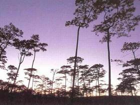
The Field of Three-leaf Pines on Phu Soi-dao
The Sightseeing Spot is a flatland on Phu Soi-dao Mountains (1,800 meters above sea level), covering an approximately area of 1,000 rai within Pa Nam-pad National Conserved Forest. The topography of the Sightseeing Spot consist of high/low hills of three-leaf pines and vast fields of lower plants. In the rainy season (August-September), some lower plants bloom thick bunches of beautiful flowers such as Ngon-nark, Goong (yellow) and Ya Rak-hom (dark purple). The Sightseeing Spot may only be accessed by walking for approximately 6.5 kilometers from Phu Soi-dao Waterfall (near the roadside of Highway No.1268) to the mountaintop of Phu Soi-dao, which will take you approximately 4-5 hours to reach there. And you can view a beautiful nature of the forests on the way to the Sightseeing Spot.