|
|
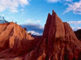
Srinan National Park is situated in an approximate area of 934 square kilometers or 583,750 rai, covering the areas of Na-muen District, Na-noi District, and Vieng-sa District of Nan Province. The geographical features of the National Park consist of high mountains, extending northwards, virgin forests, and major rain forests of Nan River, which are regarded as major water resources of people within Nan Province. The National Park is the dwelling place for a large number of wild animals and having major plants, tourist attractions and beautiful natural sightseeing spots on both sides of Nan River such as Sao-din and Cok-sua, Pak-nai, Kaeng-luang, Pha-choo, etc. The geographical features of the National Park consist of high mountains, extending northwards. Major mountains include Doi Prae-muang, Doi Khun Huai Heuk, Khun Huai Ya-sai, and Doi Luang. Doi Khun Huai Heuk, situated in the northern part of the National Park, is the highest mountaintop (1,234 meters above the medium sea level) and being the source of major gullies, flowing southward into Nan River. The National Park has natural water sources and major gullies including Khaning River, Sa River, as well as other small gullies. Doi Pha Choo View Point Enjoying the beautifu Nan River Kaeng Luang Nam Nan Pak Nai Sao Din Na Noi and Cok Sua |